If someone asks you, what is GPS? You will answer in an instant that it’s the Global Positioning System that provides you with location details of any place on the earth.
But is it only limited to that?
Well, helping you navigate through unknown roads to finding missing people, GPS tracking systems these days can track everything. It has now become the cornerstone of industries depending on the functioning of their fleets. Such industries include Public Transportation, Construction, Takeaway Services, Logistics, Courier/Delivery Services, etc.
However, GPS tracking software is not only effective for these firms but also useful for the common people.
An Introduction to GPSWOX
Trusted by 100,000+ customers across 123 countries, GPSWOX is a simple yet powerful GPS tracking software that caters to any type of business and personal needs. Its GPS server tracks heavy vehicles, bikes, boats, phones, persons, etc., in real-time and provides you with instant alerts, notifications, and other information.
Right from increasing the efficiency of drivers to identifying their problems, monitoring the vehicles, and enhancing customer satisfaction with precise arrival times, GPSWOX is the best GPS tracking software your company could have.
Salient Features of GPSWOX
1. Dashboard
As you log in to your GPSWOX account, you will see an intuitive, insightful, and actionable dashboard as below,
You can monitor your object position; get detailed information about its location, speed, coordinates, and more right on your dashboard. Besides, it lets you access all the tracking features and settings with a few clicks.

Right from giving access to a wide range of tools to set up your Object Groups (here, object refers to the GPS device you are tracking) and Drivers’ information to building SMS templates, it covers everything. Moreover, you can chat with the desired objects from the available chat window.
As GPSWOX operates across multiple countries, it ensures that you can work in your preferred language. That is why it supports 30+ languages. You can click on the flag to change the language and navigate seamlessly.
a. Tools
As the name suggests, it gives you access to a plethora of tools that will allow you to create notifications, send commands to your GPS devices, generate reports, and do a lot more.
- Alerts: It provides you with an update related to your object in different aspects. You can add various alerts for various devices. The types of alert include,
- Overspeed: Here, you can mention a speed limit that the vehicle needs to follow. In case the driver exceeds the mentioned limit, you will receive an alert.
- Stop Duration: At times, drivers tend to spend a lot of time on their journey having food or gossiping with fellow mates. As a result, the delay in delivery hinders customer satisfaction. To avoid that, you can set this alert. For instance, you set the stop duration alert to 15 minutes. If the driver stops at a place for more than 15 minutes, you’ll get an alert.
- Driver change: When the driver of an object changes, this notification helps.
- Geofence In & Geofence Out: GPSWOX can generate geo-fence. So, whenever your object drives in or out of the geo-fence area, you receive a notification.
Furthermore, you can schedule the time when the alert will be active and choose which notifications (sound, push, email, SMS, or Webhook) the user/driver will receive when a specific alert gets generated.
GPSWOX also gives you the flexibility to send a command whenever an alert generates. The user receives the commands via the GPRS network.
- Geofencing: You can draw geofence right on the map and save it. You can add as many geo-fences as needed, and edit/delete them when required. You can even import and export your geofences on another account.
- Routes: You can draw routes for different devices in a snap with GPSWOX. All you need to do is click on the points on the map, and it will create a route. You can name the route and highlight it with a color.
- Reports: The report generator tool gives you a list of report types that you can build within GPSWOX. You can choose its format and personalize the report for particular objects.
- Ruler: It shows you the distance between two points. You can drag and drop the cursor from the start to the endpoint on the map, and it will give you the distance between the two.
- Point of Interest: This lets you put your points of interest on the map. It includes a restaurant, fuel pump, car accessories store, etc. So, while your object travels through this route, it can foresee the POIs and prefer to stop at an appropriate place if required.
- Show Point: It provides you the exact view of the point you want to see in terms of degree, longitude, and latitude.
- Show Address: You can type an address, and GPSWOX will show it on the map.
- Send Command: It lets you send commands to your devices via GPRS or SMS Gateway.
- Camera/Media: If your device has a camera attached to it, this tool is where you can capture the images. This function works only when the tracker supports it.
- Tasks: It works in conjunction with your mobile GPS tracker application. For instance, you want your object to make a delivery. You can add the task with the pick-up and delivery addresses, set the task priority, define the dates, and add comments, if any, to convey a clear instruction.
- Maintenance: This tool helps you set up a vehicle maintenance schedule. Thus, it will remind you of when the next service of the vehicle is due.
- Dashboard: It gives you a comprehensive overview of your device activity, events, distance traveled by devices, and more.

b. Setup
Here, you can customize your GPSWOX platform. Right from setting up your GPS trackers to creating object groups, integrating SMS gateway, and accessing GPRS/SMS templates, it lets you set up your GPS platform.

- Main: Here, GPSWOX lets you define units of various metrics, such as Capacity, Distance, and Altitude, so that uniformity across the platform is maintained.
- Object Groups: You can group your GPS devices so you can keep a tab on a certain set of devices at the same time.
- Drivers: It enables you to enter your drivers’ information – name, a device he will drive, RFID, phone number, email, and description. This helps in case of emergencies.
- Events: Once you generate an alert, you can build custom events. This lets you define certain conditions to trigger an alert. For example, if the speed exceeds 50 km/h, trigger the event.
- SMS Gateway: If you have an SMS gateway provider, you can set it up to send commands, alerts, or notifications to your objects through it.
- SMS Templates: You can build templates beforehand for different needs so that you don’t need to type the same message every time you send a command to objects.
- GPRS Templates: Similar to SMS templates, you can use this when you send a command via the GRPS network.
- Widgets: You can choose to show or hide different widgets on the main screen of your platform.
- Dashboard: Choose what your dashboard will display and get only the information that you require.
On the left-hand side, there’s a Navigation Panel that lets you view and manage all the objects as well as their history.

a. Objects
All your object groups appear here. You can expand or collapse these groups to avail of information about any object’s location, stop duration, history, and more. Moreover, you can add any new device to the software and start tracking it. By default, it gets added to the Ungrouped Object Group, but you can move it to any of the object groups you want later on.

GPSWOX Object Panel gives you a clear idea of the object’s speed and current state in the form of the colored icons. Here is what they indicate,
- Green: An object is moving
- Yellow: The object is still, i.e., it isn’t moving but sending some data to the server
- Red: The object is offline, i.e., it isn’t connected to the system or isn’t sending data
You can also view these objects on the map in the form of an arrow that is colored similar to its state. However, GPSWOX enables you to customize the icon type and color for the state of the objects. Thus, you can easily determine the activity of your objects.

Let’s say; you want to determine the exact location of an object on the map. Simply click on that object in the Object Panel, and you will view all the details including where the device is heading, it’s street view, sensor details, driver’s information, number of hours the device stopped during the journey, and much more.
Some additional actions that enhance your GPSWOX object tracking experience include,
- History: You can view the history of all the objects for today, yesterday, and last 48 hours
- Follow: It lets you follow a particular device in real-time on a small window within the main screen. You can follow as many objects as you want simultaneously. Also, you can move the window anywhere on the platform as per your convenience.
- Send Command: In case your device isn’t sending data to the server or has lost connection, you can send GPRS commands to the device. Alternatively, you can also send an SMS, but you need to have an SMS Gateway set-up first.
b. Events
You can call it a summarization of all the notifications you get while you are surfing GPSWOX. It gives a detailed list of objects exceeding the speed limit. Hence, you can alert or warn the driver and ensure optimum safety and protection.
c. History

You can fetch the history of any object over a certain period and export it in different file formats. It lets you snap the details on the road and show/hide stop mentions in history. You can have a data log as well as a graphical representation of the history.
4. Map Control Options
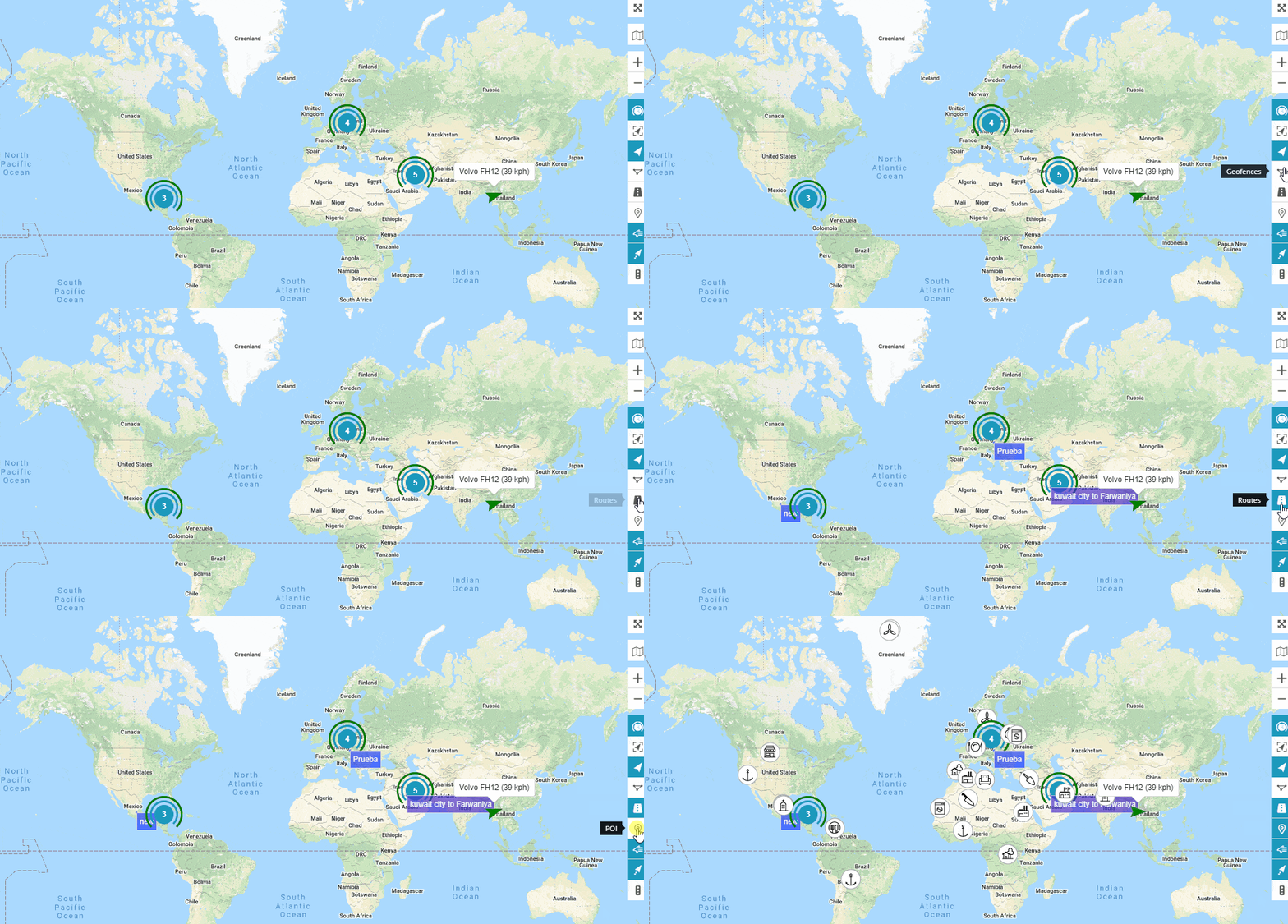
GPSWOX lets you customize your map view with a list of map features on the right side of your main screen. You can turn on or turn off these features as per your requirement. But before that, learn the functions of each here,
- Screen Mode: Clicking this will take you to a full-screen mode. Thus, what you will see is only the map and your objects; nothing else.
- Map View: GPSWOX offers 5 map views – Google Normal, OpenStreetMap, Google Hybrid, Google Satellite, and Google Terrain. You can shuffle between these views as and when needed.
- Zoom In/Zoom Out: You can easily zoom in the map and zoom out to a normal view.
- Object Groups: When you have multiple objects in a specific location, you can choose to highlight them altogether.

- Fit Objects: It will fit all your objects across various locations on one screen. Thus, you can view them all at a glance.

It also displays the device name and its speed for better insights.
- Objects: Enabling or disabling this show or hide your objects from the map, respectively.

This is useful when you have a lot of geo-fences and don’t want your objects to interrupt while monitoring them.
- Geofences: Similar to Objects, you can show/hide your geofences.

- Routes & POI: You can show or hide routes as well as Point of Interest just as below,

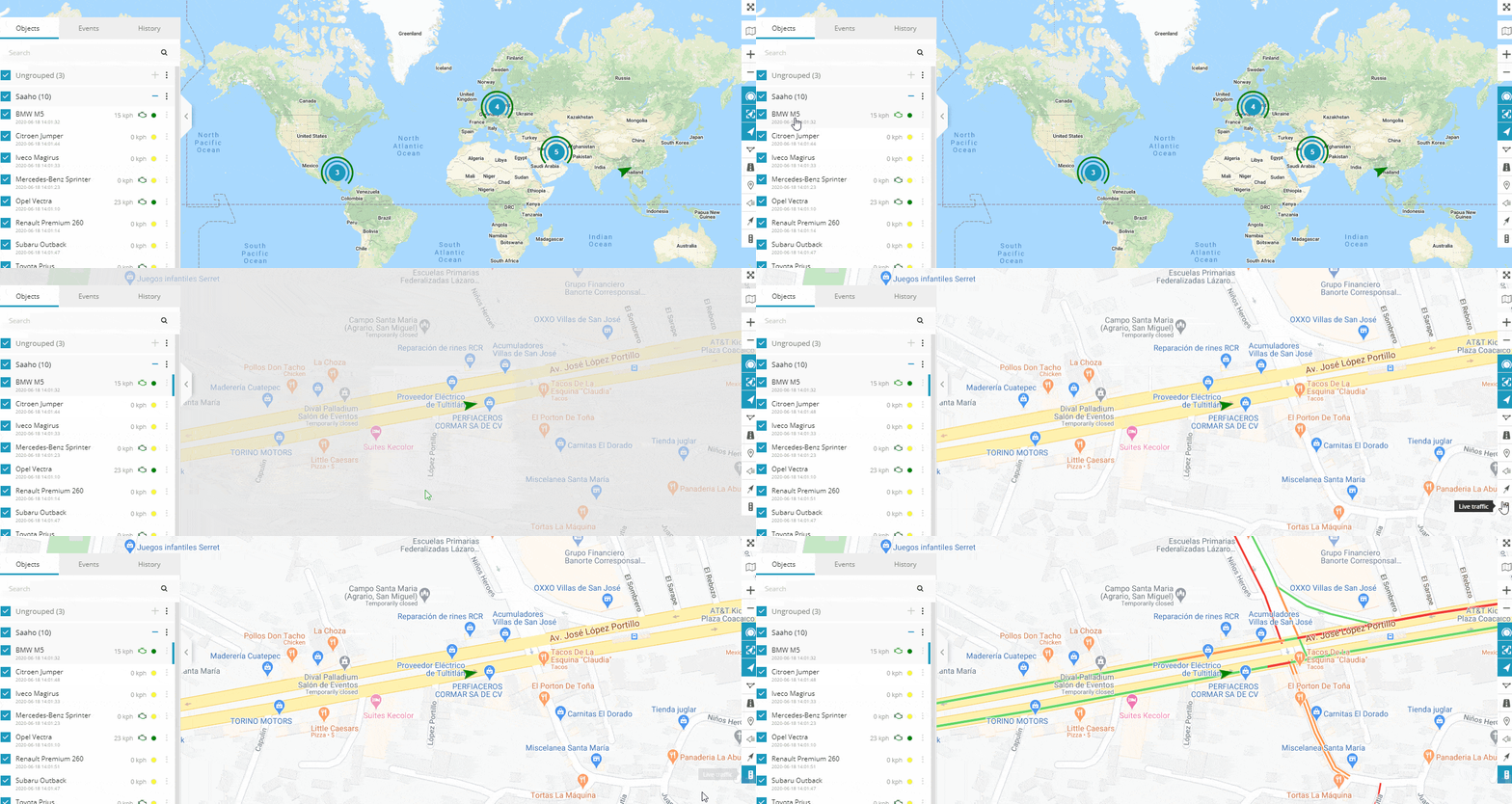
- Live Traffic: You can monitor the live traffic along your device’s way right from wherever you want.

Summing Up
Touted as the Global Market Leader providing #1 GPS tracking solutions, GPSWOX helps businesses set-up their own GPS tracking business. Right from rendering a high degree of control on drivers and vehicles to preventing delays on deliveries, GPSWOX has got the most prominent features.
With its exclusive feature set, it helps reduce road accidents and improve driving habits. Moreover, its geofencing functionality informs the company as well as the driver when they are about to enter some dangerous territories and take precautionary measures.
Above all, it supports over 900 tracking devices; thus, making fleet management a breeze. So, if you are yet to adapt to a GPS tracking system, GPSWOX is the best choice to make.
You can view more about GPSWOX on its website or its SoftwareSuggest Product Profile Page.
Need Any Technology Assistance? Call Pursho @ 0731-6725516


